 admin
admin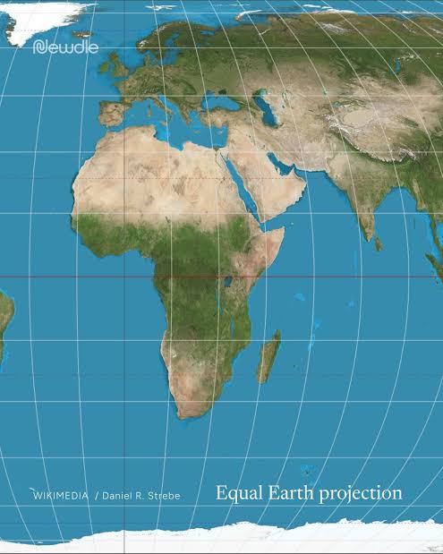
The United Nations General Assembly has endorsed a campaign to improve how the world’s landmasses are represented on maps, backing the wider use of map projections that accurately reflect the relative sizes of continents, including Africa.
The resolution, titled “Correct the Map: Rebalancing Global Cartographic Representation and Promoting Equitable Representation of the World’s Regions, Particularly Africa,” was adopted on September 4, 2026, by 164 votes to one, with six countries abstaining. The initiative was led by Togo and supported by African Union states and other countries.
At the centre of the campaign is the Equal Earth projection, a world map developed in 2018 by cartographers Tom Patterson, Bernhard Jenny and Bojan Šavrič. Unlike the widely used Mercator projection, Equal Earth preserves the relative areas of landmasses, making it easier to compare the actual sizes of countries and continents.
The Mercator projection, developed in 1569 by Gerardus Mercator, was designed to support maritime navigation by representing constant compass bearings as straight lines. However, it increasingly enlarges landmasses farther from the equator, making Greenland appear comparable in size to Africa even though Africa is approximately 14 times larger.
The distortion also affects the visual representation of South America and other regions closer to the equator. Brazil, for example, covers approximately 8.5 million square kilometres, nearly four times Greenland’s area of about 2.2 million square kilometres. Supporters of Equal Earth argue that more accurate representations can challenge misconceptions about the relative size and importance of countries across the Global South.
Advocates say maps influence how people understand the world, including their perceptions of political influence, economic strength and regional significance. Moky Makura, executive director of Africa No Filter, one of the organisations involved in the campaign, has argued that Africa does not need to be portrayed as larger than it is, but should be represented accurately.
The UN resolution does not ban the Mercator projection or require every country and technology company to adopt Equal Earth. Instead, it encourages governments, educational institutions, media organisations and technology companies to consider equal-area projections where accurate comparisons of land size matter. The decision has opened a wider discussion about map literacy, geographical accuracy and the influence of visual representation on how regions are perceived around the world.